Searching for the G/Local
katherine behar
Presented 11.11.2005. Annual Graduate Student Conference, Department of Culture & Communication, NYU.
Panel: Don't Be Evil: Political, Culture and Ethical Aspects of Google.
[Click images throughout to enlarge]
 Today I'll be sharing some work I'm doing on the subject of online mapping. The past month has shown some substantial developments in this area, notably that on October 6th Google officially merged its local search and mapping services [1] and then just last Thursday Yahoo launched a new beta [2] that follows suite. I think this is really significant — what was "Google Maps" 6 weeks ago, is now "Local Seach" — meaning that on the product level we have mapping practices and local practices getting thoroughly mixed up. My focus today will be largely on Google, and I'll be trying to show how they, as a market leader, get us to the point where we can say that mapping IS local searchability.
At the moment, we're seeing online mapping everywhere in forms ranging from Google Map Hacks and Mashups, to Data Visualization, and Bluetooth proximity apps, some of which you're looking at right now. All of these engage users at the level of the local and I will argue that this recent popularity stems in part from reconsiderations on a cultural level of ideas about "locality" and "the scope of information" in a global network.
That might sound a little tacky — these are questions we were pretty much over 5 years ago, but the web now is a very different entity than it was then. And computing, as it increasingly shifts toward mobile devices (which really throw locality for a loop), is undergoing what is arguably an even more radical transformation.
As we traditionally think of them, maps represent the world as a visual space by using systems of visual and textual descriptors. But the maps I'll be showing today don't do that. Instead of representing the world as an optical space, these maps present the world to us as information. This is not to say that they metaphorically represent the world as information but rather that they use information technologies to reconstruct cultural, linguistic, social, biological, and physical processes AS information. It is simply in their function as maps that they display that information in spatialized terms.
I'm going to show you some examples which I believe are indicative of a cultural shift toward a merging or integration of dominantly optical and dominantly informational world views. The primary case will be Google Maps but at the end we'll take a quick look at some home-grown neighborhood mapping sites which, instead of search, use folksonomy, a social categorization method that allows users to create their own keywords, tagging online content according to personal, intuitive selection.
Situated in a larger moment, online maps are a perfect synecdoche for what Siva is calling "the Googlization of everything." One of the key implications here is that online maps are not about surveillance, or any form of looking at the world, but rather they are about processing the world as a form of information.
Google Maps
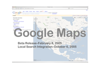 Google Maps was released in Beta on February 8, 2005 and was, like many of Google's Beta projects, an immediate popular success.
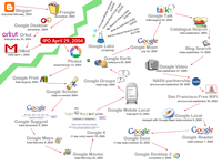 To put this in context, this slide shows some of the Google releases, betas, and Google Labs projects that have come out either since or just before its IPO on April 29, 2004. [3] In thinking about these projects it's helpful to consider that Google's corporate mission is to "organize the world's information and make it universally accessible and useful." [4]
When Google got started in March of 1996, this mission pretty clearly referred to information that was part of the WWW, meaning that the "world's information" was stuff that was already online. But as some of these recent projects show, things that now qualify as fair game for Google to organize and universalize — that is what gets considered "information" — include things that are offline and part of the physical world as well.
Now to just to prove that I'm not giving you some crazy conspiracy theory about Google's trying to take over the world, Google's CEO, Eric Schmidt has recently given an ETA of 300 years until Google indexes and organizes ALL of the world's 5 million terabytes of information (they've got 170 now). [5] What's shocking about that is not that that's a "really really long range plan," but that it's a plan: they're doing what he calls "math experiments" about it now.
So, the process of "making [the world's information] universally accessible and useful" begins by first conceiving of the world as information — and secondarily bringing that information online (that is incorporating it into the informational world known as "cyberspace"). And this two-step process (first modeling the reality, then acquiring the data) is precisely what Phil Agre calls "capture."
Capture
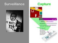 In his essay "Surveillance and Capture: Two Models of Privacy" (1994), Agre distinguished between two cultural models: "surveillance" and what he calls "capture." [6] It's easy to understand the surveillance model as essentially like "Big Brother is watching you;" but a good example of the capture model is something like EZPass — where an RFID tag is coupled with a vehicle and sensors monitor the RFID tag and, by extension, track the vehicle. [7] This is significantly different from Big Brother, not only because is it's an opt-in system, but there are no cameras involved, just information passing from RFID tag to RFID reader to computer.
Capture can be defined as follows: it involves a computer that is set up to model a real world social organization. Entities in the social and computer systems are correlated, then movements on the social end are tracked and updated on the computer end, resulting in a realtime simulation. —That is, a realtime, informational model.
The project Google is undertaking is exactly what Agre's capture model is all about, and I want to emphasize that it is not well understood by optical models like surveillance or the visual descriptive function of maps, traditionally conceived. So despite the satellite images I'm about to show, this is not about surveillance. It's about informational processing, not vision. So please bear this in mind as we look at some of Google Maps's key features.
Features: Views
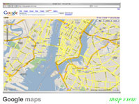 Google Maps uses three views. [8] The default view, here, is "Map View" which is what I call a planner's view that shows computer-rendered, named streets from a disembodied overheard viewpoint, which lacks optical perspective. I call this the planner's view because it uses analytical rhetoric derived from a system of calculation, probability, and efficiency to make claims about a modeled informational world.
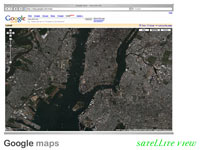 The next view is "Satellite View," a camera's view, showing compiled satellite imagery that has to date been most frequently associated with military surveillance and reconnaissance. I call this the camera's view because it uses optical rhetoric derived from a system of lenses, light, and refraction to make claims about a recorded visible world.
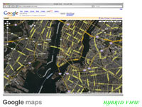 But, the most consequential view in my mind, is this one: "Hybrid View," which, as you can see, superimposes the planner's and camera's views. Hybrid view is incredibly substantial to my mind, because in this overlay, there is a tremendous leap of faith. We are being asked to accept that these two things — informational and optical representation — are compatible. Note that in the upper right hand corner of the Google Map, there are controllers to allow us to toggle between the three views. We are supposed to think that the overlay works and that toggling works, because "they're all really showing the same thing."
And this is where to me things get really interesting... because Google is, of course, a search company. The question to ask is: what does making this type of integration enable us to find?
Features: Local Search
 The next feature to consider is "Local Search," which aims to render the "local," inhabited world searchable and accessible as information. [9]
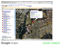
As I mentioned, Local search was fully integrated with Google Maps on October 6, 2005. The services are now synonymous, evidence that Google intends for Local Search, rather than something like driving directions, to be the most important of the Maps features. Local Search allows users to search for "a what in a where" — that is to search by keyword within a locality to return results of "real world" features. This slide shows a search for "bars in Brooklyn." Ranked results are listed at the left of the page as text links that correspond to "map pin" icons, which visually affix the search data to the map surface by indexing it to a geographical location. Clicking a link at left, or a map pin marker opens an information bubble containing a local search result including a portal link to the offsite hit.
Now this is key: it is only through accepting the premise behind the hybrid view — the integration of optical and informational contexts — that local search is possible. When one searches for "a what in a where," the "where" is indexed to the world being visually represented on the map, which is the world of optics in which we operate bodily and locally. The "what," however, is part of the informational world — it's a link in cyberspace. When I click on a local search result link, I do not "go" to the "where's" address, I "go" to "what": a website that contains that address as a text string. There's a serious conceptual hiccup in there, evidenced when, as frequently, the general content of the webpage has little semantic connection to the search.
Key Concepts
In short, what I think we see in the case of Google Maps is the use of visual representation (the camera's Where) as a structure for information (the planner's What). And it is an example of the visible world's being portrayed as having informational properties (precisely their "Hybridized" integration).
Folksonomy-based Neighborhood Mapping
Local Search is the organizing principle behind online mapping in the hands of major search engines. But there are other ways of organizing information on a map and one reason I think online mapping has captured so much of the popular imagination is that big corporations aren't the only one's doing it. Both Yahoo and Google opened their APIs which encouraged a flurry of mashups and map hacks, like some of the images I was running in the beginning — and that's definitely a subject for another talk. But what's interesting to me is that you don't have to be either a multinational corporation with powerful search algorithms or even a hacker to participate in this. And here's one way how:
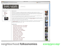
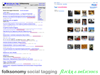 Folksonomy is a social categorization method in which users pick freely-chosen keywords. Basically, it works like stream of consciousness fill in the blank and can be used to organize any kind of online data from bookmarks at Delicious [10] like I'm showing on the Left, to photo-sharing at Flickr [11] shown on the right. This is an inherently bottom-up, user-centric, social, emergent way of organizing information. And certainly, because it rests entirely on users, folksonomy's content and processing logic are 100% local. Moreover, as an organizing principle, folksonomy seems to encourage a locally-situated feature I'll call "sentiment" — note that the Flickr photos are one's that have all been tagged "uncomfortable" by users — this is an overtly subjectivist form of data organization that we won't see in any keyword system that aspires to global relevance.
I'll show just three folksonomy-based neighborhood mapping sites, simply to demonstrate that information capture is limited neither to Google Maps nor to the corporate sector.
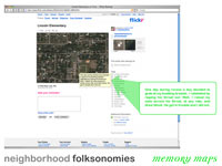 In my opinion, examples like this one, from the Memory Maps pool at Flickr.com, [12] amount to a kind of homebrew, DIY capture. Folksonomy's tagging structure is informational annotation. [13] The maps provide an architecture for uploading and organizing those annotations, which are precisely information "about" a neighborhood.
Examples
With Memory Maps, a user-invented use of Flickr's folksonomy and Google Maps' satellite imagery, users are annotating autobiographical narratives to Google Satellite images and uploading them to Flickr with a "Memory Maps" folksonomy tag. This tag associates their Memory Map with the Memory Maps of other users. Memory Maps use Google Map images but exist solely at Flickr.com.
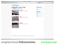
 The next slides show Whereyouare.org, a site that provides a tagging protocol through which it aggregates user-contributed neighborhood data from across a number of media and from a number of remote web services. [14] Using unique strings of "ur+zipcode+countrycode" as folksonomy designations, Whereyouare.org asks users to document their neighborhoods at other folksonomy-based sites by creating and tagging neighborhood-specific Flickr photos, Vimeo videos, Foundcity finds, and Delicious links. he Whereyouare website does not host this content, but rather acts as an aggregator for these services.
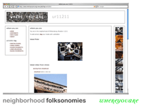
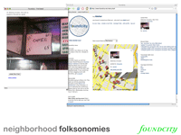 And lastly, this is Foundcity.net, a project that accepts user-supplied content and associates it with a location on a Google Map. [15] Foundcity receives content from cell phone messages. "Finds" (as in "What a great find!") can be sent to city-designated email addresses including a picture message, with the folksonomy tags and address information in an accompanying text message. The find you're looking at here is 65 cent coffee just blocks from my house.
Key Concepts
These are just three examples, and for lack of time I would like simply to pose the following question: To what extent does it matter if Google captures satellite images or individuals capture cell phone images?In either case, this is capture in a nutshell and maps, I think, are a key component to orienting us to an informational world. They're the link between searching for the "world's information" and processing our own localities as information.
Conclusion
 When capture models the world as information, it makes an ontological claim about operational compatibility at the local level. As Google googlizes more and more "world," locality is touted as a means of stemming information overload. The world has got too much information to be useful to humans which is why optical access is out. A Google employee recently said, "We are not scanning all those books to be read by people ... We are scanning them to be read by an AI." [16] The answer seems to be "Index Global, Search Local," a scenario in which the informationally local — that is "search relevance" — is understood in as a situational process.
References
[1] http://www.eweek.com/article2/0,1895,1867783,00.asp.
[2] http://maps.yahoo.com/beta/index.php.
[3] http://googleblog.blogspot.com; http://searchenginewatch.com; http://en.wikipedia.org/wiki/List_of_Google_services_and_tools.
[4] http://www.google.com/corporate/index.html.
[5] http://news.com.com/Google+ETA+300+years+to+index+the+worlds+info/2100-1024_3-5891779.html.
[6] Phil Agre, "Surveillance and Capture," The New Media Reader. Noah Wardrip-Fruin and Nick Montfort, eds. (Cambridge: MIT Press, 2003) p. 737-760.
[7] http://www.zapped-it.net/info.html; http://www.ezpass.com.
[8] http://maps.google.com.
[9] http://local.google.com.
[10] http://del.icio.us.
[11] http://www.flickr.com.
[12] http://www.flickr.com/groups/memorymaps/pool.
[13] http://www.shirky.com/writings/ontology_overrated.html.
[14] http://www.whereyouare.org.
[15] http://www.foundcity.net.
[16] http://www.edge.org/3rd_culture/dyson05/dyson05_index.html.
) Today I'll be sharing some work I'm doing on the subject of online mapping. The past month has shown some substantial developments in this area, notably that on October 6th Google officially merged its local search and mapping services [1] and then just last Thursday Yahoo launched a new beta [2] that follows suite. I think this is really significant — what was "Google Maps" 6 weeks ago, is now "Local Seach" — meaning that on the product level we have mapping practices and local practices getting thoroughly mixed up. My focus today will be largely on Google, and I'll be trying to show how they, as a market leader, get us to the point where we can say that mapping IS local searchability.
Today I'll be sharing some work I'm doing on the subject of online mapping. The past month has shown some substantial developments in this area, notably that on October 6th Google officially merged its local search and mapping services [1] and then just last Thursday Yahoo launched a new beta [2] that follows suite. I think this is really significant — what was "Google Maps" 6 weeks ago, is now "Local Seach" — meaning that on the product level we have mapping practices and local practices getting thoroughly mixed up. My focus today will be largely on Google, and I'll be trying to show how they, as a market leader, get us to the point where we can say that mapping IS local searchability.)
)
)
)
)
)
)
)
)
)
)
)
)
)